

Join
Programs
About


NRC and EllisDon applied an integrated BIM-based digital delivery framework to the $1.6-billion Place du Portage III renewal, combining reality capture, coordinated BIM, an ISO 19650-aligned common data environment, 4D sequencing, and NRC's NBLA openBIM-LCA application to improve coordination, productivity, lifecycle information, and carbon decision-making.

Place du Portage III (PDPIII) is Public Services and Procurement Canada's (PSPC) $1.6-billion renewal of a 1.3-million-square-foot, nine-tower federal complex originally built in the 1970s. The project must replace major base-building systems, modernize workplaces, support accessibility and sustainability upgrades, and progress through complex phasing while maintaining operational continuity. In this setting, conventional document-centric delivery creates significant risk: incomplete or outdated information about existing conditions, fragmented coordination across disciplines and sub-consultants, and data that is difficult to reuse for carbon assessment, handover, and future operations.
For rehabilitation, these risks are amplified because new work must interface with an existing structure and systems that may differ from legacy drawings. Unverified conditions can lead to design conflicts, rework, delays, and safety or access constraints. At the same time, the project's net-zero carbon objectives require material, quantity, and performance data to be available in structured form rather than reconstructed manually after major design decisions have been made.
The challenge was therefore not simply to introduce BIM software. It was to establish a reliable digital information-management environment that connects physical reality, multidisciplinary models, project coordination, construction sequencing, carbon analysis, and lifecycle asset data. NRC and EllisDon addressed this challenge by developing and demonstrating an integrated, standards-aligned digital workflow on the PDPIII renewal.
The NRC and EllisDon team implemented an end-to-end digital delivery system on Place du Portage III and codified it as a five-stage framework aligned with ISO 19650: define goals and information requirements; establish the BIM Execution Plan and Common Data Environment; deploy and monitor; measure and improve; hand over validated data for operations.
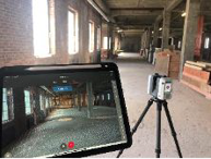
Reality capture and scan-to-BIM: LiDAR scanning and photogrammetry produced point clouds as the verified baseline of existing conditions; design models were checked against them so new systems such as HVAC ducting fit the 1970s structure before fabrication. Managed coordination: all discipline models were federated weekly within the CDE; automated checks flagged hard and clearance clashes, tracked in Autodesk Construction Cloud and resolved virtually before reaching site.
ISO 19650 CDE: Autodesk Construction Cloud and Tandem served as the single source of truth for nine towers and dozens of sub-consultants, with strict naming and metadata conventions, and WIP–Shared–Published–Archive states as an audit trail.
4D phasing: schedules were linked to the models to rehearse construction fortnightly, surfacing time-space conflicts early and protecting occupant movement through the phased transition.
BIM-enabled carbon monitoring: material quantities were extracted from the IFC model and mapped to life-cycle inventory datasets in NRC's NBLA openBIM-LCA application, with an open-source model checker validating each IFC file against carbon-quantification requirements — enabling whole-building LCA in real time as the design evolved.
Governance ties it together: named roles, gates, acceptance thresholds, and hybrid KPIs that measure productivity and carbon alike.


